Meteorological Synoptic Analysis
On the afternoon and evening of February 26, 2023, an outbreak of severe weather erupted across portions of the Southern Plains. Most of the severe weather, which included 15 tornadoes, developed initially in the late afternoon across the Texas Panhandle before tracking into Southwest Kansas, Western and Central Oklahoma by late evening and then eventually moving into western Missouri shortly after midnight. At least 9 tornadoes occurred in OK based on preliminary information from the Storm Prediction Center , which shattered the previous February record of 6 tornadoes in OK back in 1975 and 2009. Figure 1 is a preliminary map of the confirmed tornado damage across Central OK from the NWS in Norman.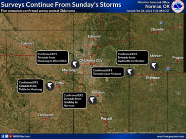
The storm environment was primed as the result of a dynamic, negatively tilted mid and upper level shortwave trough of low pressure ejecting out of the southwestern U.S., which was accompanied by a belt of strong winds of 65-75 kts at 500 mb by 0000 UTC on 2/27/23 across portions of the southern plains. The extreme wind shear from low to mid levels produced enlarged hodographs possessing 74 kts of shear from the surface (SFC) to 6 km and 563 m2/s2 of storm relative helicity (SRH) in the SFC to 3 km layer, due to both speed shear and impressive direction shear. SRH from the SFC to 1 km was very impressive at 427 m2/s2 based on the observed 0000 UTC Norman, OK (OUN) sounding (Figure 3) which allowed thunderstorm updrafts to rotate quickly. At the surface, there was a warm front lifting northward across southern Oklahoma ahead of the main cold frontal boundary and surface low in TX panhandle and western KS. (See analyzed surface map in Figure 2).
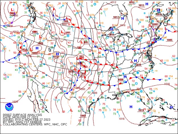
Figure 2. Surface analysis at 0000 UTC 2/27/23 (From: NOAA/WPC)
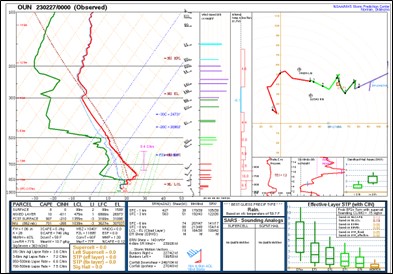
Figure 3. Observed 00Z upper air sounding from Norman, OK (OUN) on 02/27/23
The low-level moisture had been gradually increasing throughout the day across OK as the warm front was lifting northward with 60 deg F dewpoints observed at OUN by 0147 UTC. Surface temperatures had also increased but never got above 65 deg F even by the time storms approached central OK. Thus, surface-based instability was very limited and parcels were being lifted from above the capping inversion which extended to approximately 3 km. (Note: MUCAPE = 701 J/Kg). Updraft helicity (UH), defined as the vertical integral of the product of vertical velocity and vertical vorticity between two levels, is commonly used as a proxy for mid-level rotation potential in supercells.
The expected storm evolution for Feb. 26 was for discrete supercells to form initially along a dry line in the Texas Panhandle and then grow upscale to a quasi-linear convective system (QLCS) and produce a derecho with widespread wind damage. Upscale growth did occur as storms quickly merged and formed a large QLCS in western OK/southwestern KS by 2100-2300 UTC , but due to the fact that UH was so extreme in the 2-5 km layer (See Figure 4), even extending well above the inversion, storms whose updrafts that remained along the line formed mesovortices with rotating couplets in the 2-5 km layer with potental for tornadogenesis.
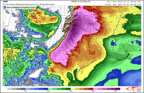
Figure 4. The High Resolution Ensemble Forecast (HREFv3) from 0000 UTC 2/27/23 run showing a 3 hr forecast of the ensemble mean of 0-3 km SRH (m2/s2) with MAX UH (2-5km) > 75 tracks in brown (From: SPC Storm Scale Ensemble of Opportunity (SSEO) web page)
Shear was so strong that it dominated convective processes and kept the line from becoming cold-pool dominant. A 3 hour forecast RAOB sounding from the High Resolution Rapid Refresh (HRRR) Model is shown in Figure 5. While the capping inversion was still present the extreme low-level shear had increased to almost 450 m2/s2 in the lowest 1 km in the Norman area. DCAPE was also very high (960 J/kg) which suggests downdraft columns of air had high potential for producing damaging winds upon descent to the surface.
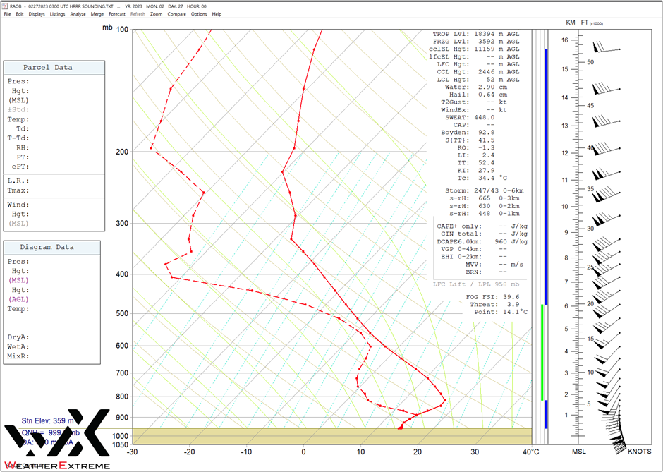
Figure 5. A 00 hour forecast sounding valid at 0300 UTC from the High Resolution Rapid Refresh (HRRR) Model. (From RAOB)
The formation process for QLCS tornadoes is slightly different than for supercell tornadoes. While most supercell tornadoes form through a process of tilting of horizontal vorticity into the vertical and then streched by the updraft forming a mesocyclone, which then descends based upon temperature changes across the edge of downdraft air wrapping around the mesocyclone (Markowski, 2008), a QLCS tornado is thought to be initiated by internal processes resulting in mesovortex formation from upward or downward tilting of environmental or baroclinically generated horizontal vorticity along a line. It is thought that low-level vertical vorticity is generated through these tilting processes and then may also combine with vertical vorticity generated along gust fronts through the tilting of environmental horizontal vorticity to aid in mesovortex genesis. Mesovortex genesis through these tilting processes has been shown to depend on the existence of sufficient environmental vertical wind shear, which supports the development of upright updrafts via a balance between the QLCS cold pool and environmental vertical wind shear (See Marion and Trapp, 2021).
Storm-Scale Analysis
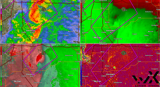
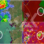
Figure 6. GR Analyst L2 data from KTLX at 0327 UTC on 03/27/23. Radar products shown in quadrants clockwise from upper left: 0.5 Reflectivity, 0.5 deg Velocity, 0.5 Correlation Coefficient, 0.5 Storm-relative Velocity. Mesovortex and tornado debris signature identified. NWS Tornado Warning polygons overlaid.
As storms merged into a line across central OK, there were several areas where mesovortices developed where the cold pool and wind shear were in balance. These conditions helped to spawn an outbreak of QLCS tornadoes, which are typically much shorter lived than supercell tornadoes due to the fact that the updraft persistency is much shorter. Researchers have found that the primary contributor to QLCS tornadoes being weaker and shorter-lived than supercell tornadoes is the lack of persistency of the QLCS cold pool and associated dynamics. There was one QLCS mesovortex which rapidly formed just south of Norman along the line near Goldsby, OK at 0300 UTC and quickly intensified and produced a tornado which tracked for approximately 26 miles into East Norman and produced up to EF-2 damage (Note: The Enhanced Fujita (EF) Scale considers a EF-2 tornado as a strong tornado with estimated wind speeds of 111 to 135 mph).
The radar image at 0322 UTC from KLTX (Figure 6) shows the mesovortex and associated tornado debris signature over east Norman where some of the most intense damage occurred. A tornado debris signature (TDS) was indicated on radar for several volume scans and since the storm passed so close to KTLX the debris signature was present up to 5860 kt (ARL). The tornado continued moving northeast at 50 mph across eastern Cleveland County. A video loop of GR Analyst Level 2 radar data shows the evolution of the tornado producing mesovortex that stayed in contact with the ground for 26 miles. The tornado lifted briefly but then touched down a few minutes later north of Shawnee, OK around 0345 UTC and also produced EF-2 damage. The photo shown in Figure 7 depicts an example of the EF-2 damage in the east Norman area. A drone video surveying the some of the significant damage path in Norman is available at https://www.foxweather.com/watch/play-63d42cc1f0016b9
Summary
On the evening of Feb. 26, 2023, an outbreak of QLCS tornadoes occurred in central OK including some strong long-track tornadoes in the Norman area. These storms originated from a convective line in western OK. These storms were not rooted in the surface layer but possessed extremely large shear and low-level helicity which, when updrafts remained anchored to the cold pool were able to generate very strong mesovortices and subsequent tornadoes. These type of cool season QLCS events have been documented to be able to produce some of the higher-end QLCS tornadoes due to extreme environmental low-level shear and updraft helicity.